


Azraq Basin
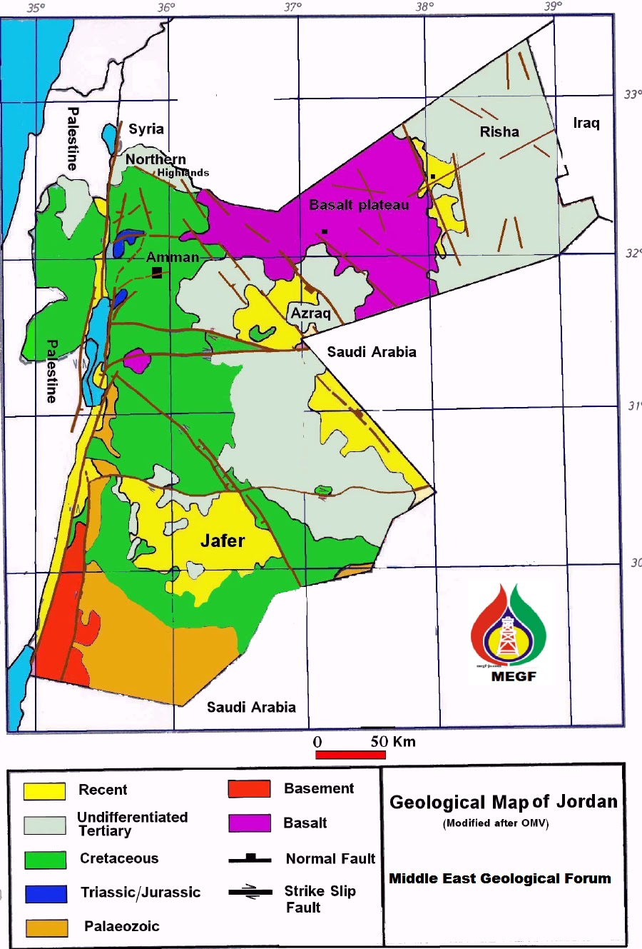
LOCATION AND GEOLOGICAL SETTING
Stratigraphy
The Turonian rocks (Wadi Es Sir Formation)
consist of 360 meters of white to light gray limestone microcrystalline and
thinly bedded with very thin marl partings, fractured fossilifrous, and medium
hard to hard limestone, interbedded with thin beds of anhydrite
and medium beds of dolomite and dolomatic limestone.
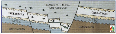
A major unconformity (Hercynian) separates the
Paleozoic from the overlying Mesozoic in all Jordanian basins. The unconformity cuts deeper following an
east to west trend. Several other unconformities occurred during the Mesozoic.
These are characterized by peneplanation surfaces and sands with good reservoir
quality clastic driven from the Paleozoic and Precambrian
basement rocks.

Structural Framework of Azraq Basin

Surface geology, Landsat interpretation, well data and seismic interpretation indicated that, NNW/SSE, NW/SE and ENE/WSW trending faults characterize Azraq basin. It is widely believed that NW/SE sinistral faults such as, Fuluk, are related to the Najd Fault system. The Fuluk growth fault is the main structural element responsible for the development of a NW-SE trending asymmetrical graben with significant thickening of Cretaceous and Paleogene sediments. The sedimentary section reaches a maximum thickness of approximately 5500 meters in the vicinity of this fault, where as the vertical throw is more than 2500 meters (8ooo feet) to the southwest. In the Basalt Plateau, they are marked by some Basalt extrusions of younger age of the surrounding Basalt, indicating tensional tectonics rejuvenation along these faults. This trend may be, in part, associated with post Oligocene left lateral wrenching along The Dead Sea Transform (DST), it may also represent a rejuvenation of more ancient fracture associated with NW/SE strike slip faulting occurred in the Arabian Shield or Azraq Sirhan Basin during pre- Cambrian time.Siwaqa fault is an E/W striking dextral fault crossing the Jordan Platform for 200 km form the Dead Sea fault to Saudi Arabia. Siwaqa fault marked the southern limit of Azraq Basin. As any other E/W fault in Jordan, Siwaqa fault shows strong structural deformation, associated with major right lateral strike slip and variable dip throw. In the Pre – Cretaceous, the north of the Siwaqa fault was high block, where erosion cut deeply into the Paleozoic resulting in Ordovician underlying Cretaceous, however, the area was the site of thick sedimentation during the Cretaceous. This structural inversion resulted in separating the Azraq Basin from the Larger Sirhan Azraq basin.

Hamza oil field is a narrow elongated E/W tilted horst
block. The oil is produced from the Cenomanian Shueib and Hummer formations. By
now only 826000 barrels of oil was produced. Geochemical studies indicate that 430 million barrels of oil was
generated in Azraq Basin out of which 43 millions was trapped.
A second type of oil was most likely generated
indigenously in the Upper Cretaceous Ghareb and Amman formations. This sulfur
rich oil formed at a relatively early stage of maturation.

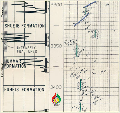
Fractures are playing very important role in terms of
productivity and migration pathways in Hamza oil field. Detailed micro
tectonics study of 600 meter/cores showed that, the porosity and permeability
of Cenomanian reservoirs are drastically enhanced by widespread fracture
network. Three sets of fracture were recognized creating rubble zones and sweet
spots. These fractures mostly open, wide angled and oil stained. Both
reservoirs show strong fracture intensity ranges from 2 fractures to 20
fractures per meter. The density and distribution of these fractures are
function of the structural attitude and history.

LOCATION AND GEOLOGICAL SETTING
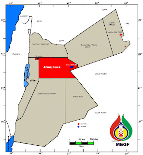
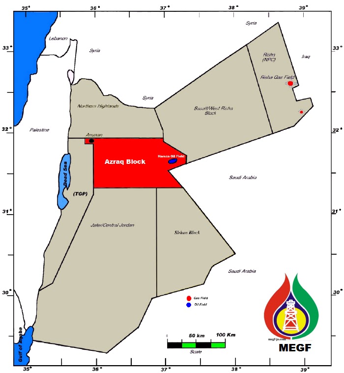
Azraq basin is a 1500 Sq.km. NW striking, structurally
controlled Cretaceous basin. It is located in Amman / Azraq Block (11250
Sqkm.). It lays 120Km to the east of Amman; between the high central plateau in
the west and the Basalt Plateau in the east. It is the only proven oil province
in Jordan yet. It contains the small Hamza Oil Field, which was discovered
after a successful completion of Hz-1 Well in 1984.
Stratigraphy
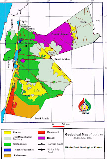
Rocks of Tertiary to Quaternary age with some basalt
cover the studied area. It consists of limestone, silicified, marly in parts
phosphatic argillaceous partly marly with nodules of chert and loose sand. The
exposed thickness of these rocks is in order of 100 - 300m.On the other hand,
the distribution of these rocks in the subsurface is rather complicated and
associated with neo – tectonics. It varies from zero in the most eastern part
to 850-1000 meters in the central part and to 600-800meter at the NW part of
the basin. This complex pattern indicates a NW / SE faulting where Hamza Field
is located in the deepest part of the basin.
The deposition of 150 m of
Alb/Apt. Kurnub sandstones marked the beginning of the Cretaceous in Azraq
Basin. It consists of fluvial and
deltaic sandstones intercalated with marl, black shale and rarely dolomitic
limestone occurs at the base of this formation.
The Camp / Santonian consist
of two formations (Upper & Lower Amman)
, a 700m of brown finely crystalline, compact, silicified dolomite and
limestone were deposited. The Santonian is marked by 500m of red clay and
sandstones.
Finally, the Cretaceous was
ended by the deposition of 700m of the Mastrichtian (Ghareb) argillaceous,
marly and fossilifrous limestone and (Oil shale).
Both, Mastrichtian and
Campanian / Santonian carbonates have heavy oil and asphalt especially when
they are fractured.
The Jurassic rocks which was
drilled by limited number of wells in Hamza oil field and Azraq Basin, are made
up of colorless, friable well-sorted sandstone and dark gray thin beds of
fissile, shale. The drilled thickness of the Jurassic rocks is 30 meters.
Triassic rocks in Azraq basin
are composed of 300 meters of thin beds, well sorted bituminous in parts
sandstone, and thin beds of fissile, dark gray shale interbedded with beds of
brown, compact limestone and dense, buff, fine crystalline dolomites.
Most
of the upper Ordovician (Dubaydib Formation) is eroded in Azraq Basin. The
remainent section of Ordovician is composed of 300meters sandstones, colorless,
siliceous cemented, hard, cemented sandstone interbedded with gray hard
siltstone and thin beds of sandstone well sorted friable and ill cemented, with
beds of weakly fissile calcareous shale.

Stratigraphic Column of Azraq Basin
The Cambro/Ordovician rocks of Umm Sahem and
Disi sandstone (1200m), consist of colorless, medium hard, fine to medium
grained silty in parts, sub rounded sandstone, intercalated with thin beds of
brown, soft, sandy silts, and streaks of medium hard compact weakly fissile
shale. Wadi Ghadaf-2 well penetrated 500 meters of Cambrian rocks and was
abandoned dry in Early Cambrian Salib sandstone formation. During Middle
Cambrian (Burj formation) marine conditions were prevailing which resulted in
deposition of 160 meters of Dolomite and siltstones of Burj formation.
The Precambrian Saramuj (Basal)
conglomerates were not penetrated completely or partially by any well in Azraq
Basin.
To sum up, the lithological
column of Azraq basin provide multiple chances to have source, reservoir and
seal intervals.
Structural Framework of Azraq Basin
The Azraq Basin is bounded, by
the high central plateau and the northern Highlands in the west and northwest,
and by the Basalt Plateau in the east and northeast. It is flattened and
covered by Paleogene and Neogene rocks. The elevation within the study area varies
from 530m ASL to 650m ASL. This 1500 square km, asymmetrical half graben and
structurally controlled Late Cretaceous basin is striking to NW/ SE direction.
It is limited to the north and east by Fuluq fault and to the south by Siwaqa
fault, to the west the strata rises gradually into the Northern Highlands. The
basin is deepest in the east and northeastern parts, adjacent to the down
thrown side of Fuluq fault.

Structural Framework of Azraq Basin
Surface geology, Landsat interpretation, well data and seismic interpretation indicated that, NNW/SSE, NW/SE and ENE/WSW trending faults characterize Azraq basin. It is widely believed that NW/SE sinistral faults such as, Fuluk, are related to the Najd Fault system. The Fuluk growth fault is the main structural element responsible for the development of a NW-SE trending asymmetrical graben with significant thickening of Cretaceous and Paleogene sediments. The sedimentary section reaches a maximum thickness of approximately 5500 meters in the vicinity of this fault, where as the vertical throw is more than 2500 meters (8ooo feet) to the southwest. In the Basalt Plateau, they are marked by some Basalt extrusions of younger age of the surrounding Basalt, indicating tensional tectonics rejuvenation along these faults. This trend may be, in part, associated with post Oligocene left lateral wrenching along The Dead Sea Transform (DST), it may also represent a rejuvenation of more ancient fracture associated with NW/SE strike slip faulting occurred in the Arabian Shield or Azraq Sirhan Basin during pre- Cambrian time.Siwaqa fault is an E/W striking dextral fault crossing the Jordan Platform for 200 km form the Dead Sea fault to Saudi Arabia. Siwaqa fault marked the southern limit of Azraq Basin. As any other E/W fault in Jordan, Siwaqa fault shows strong structural deformation, associated with major right lateral strike slip and variable dip throw. In the Pre – Cretaceous, the north of the Siwaqa fault was high block, where erosion cut deeply into the Paleozoic resulting in Ordovician underlying Cretaceous, however, the area was the site of thick sedimentation during the Cretaceous. This structural inversion resulted in separating the Azraq Basin from the Larger Sirhan Azraq basin.
Folds are the least impressive surface structural element
in area Practically, they are absent; except for usually small compressional,
sharp undulations, uplifted anticlinal blocks and arched sets of narrow blocks
parallel and/or oblique to the major fault trends (WNW/ESE) associated with
NNW/SSE. Neither type of fold is expected to be large.
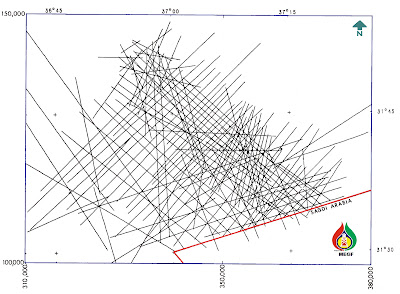
Seismic coverage of Azraq Basin
Azraq Basin was subjected to intensive and multiple seismic programs
between 1969 and 1988. A total of 7174 km of good to excellent seismic data are
available at the NRA head office. The bulk of this data has 24 folds and 48
traces. Recent data have 48 and 60 folds with 96 and 120 traces. All data were recorded using Vibroseis as the
seismic source. About half of the data were recorded with 100-meter group
intervals. The most recent data were recorded with 60-meter interval. When
these data were redisplayed and interpreted, they show strong expression of
wrench tectonics and structures. add to this 300Sqkm. of excellent quality seismic data was acquired in 2010.
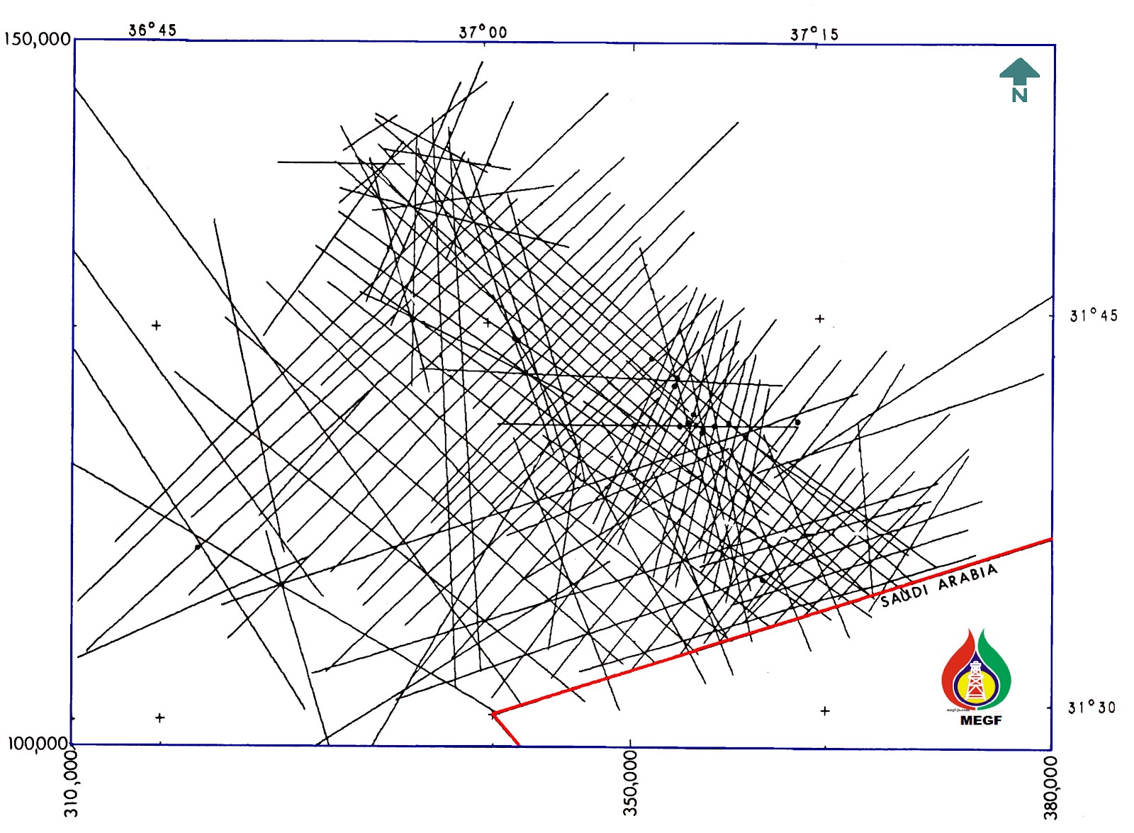
Seismic Coverage Map
(Azraq Basin)
Structural Style and Trapping Mechanism
In spite of it’s diverse
structural styles and long structural history, Azraq basin provides a vast
range of potential hydrocarbon traps,. The traps in this basin are fault
controlled structural features of relatively small size. Possible reservoirs
are found in Lower Cretaceous Kurnub sandstone, Cambrian Sandstones and in
Campanian Azraq sandstones. The proven oil bearing reservoirs are
Cenomanian-Turonian fractured limestones and dolomites of the Shuieb and Hummar
formations. Source rocks are interbedded Cenomanian and Turonian limestones and
marls locally Wadi Essir Formation (WS2 member).
In addition to the proven oil accumulation in the down
thrown side of the Fuluk fault, there are shallow prospects on the up thrown
block to the east, where the structural style is one of rotated fault blocks
controlled by antithetic fault trends associated with the major fault. A series of compressional anticlines is found on
the down thrown side of the southern E-W boundary fault of the basin (Siwaqa
Fault), these anticlines trend in an east-west direction. Several high-level
closed anticlines have been mapped at the western up-dip margin of the Azraq Graben. They represent good
targets at shallow depths, since they lie on possible migration pathways from
deep basinal areas.

Drag Fold in the Upper
thrown Faulted Trap
Based on the structural characteristics and history of
the Basin, one can concluded that, two structural styles are dominating the
study area, they are: -
1- Normal faulting
2- Wrenching
The following trap types are expected:
I) Normal Block Faulting
-
Horst Blocks
-
Tilted Faulted Blocks
-
Drag Folds
-
Graben Associated
Structures
-
Graben Self Contained
Traps
II) Compressional Wrenching
-
Rotated Fault Blocks
-
En Echelon Folds
-
Positive Flower
Structures

Example of Tilted Horst Block Trap
Add to the above, faults in the basin are mostly
sealing, thus preventing horizontal fluids migration out of the reservoirs. Fractures
are playing a very important role in enhancing the reservoir quality and
providing additional permeability to already low permeable
Upper Cretaceous carbonates. On the other hand, the fractures are potentially
important fluid migration pathways, thus greatly influences the hydrocarbon
distribution in the basin.

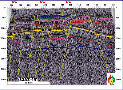
Fault Related 2D Structural Anomalies
Oil Habitat and Hamza Oil Field
The Azraq basin has been the site of the early drilling
activities undertaken by NRA at the beginning of the eighties. Following the
oil discovery at Hamza-1 location seventeen (17) wells has been drilled, these
included exploration delineation and production wells. More than 13 wells were
drilled in other parts of the basin. Recent seismic interpretation indicated
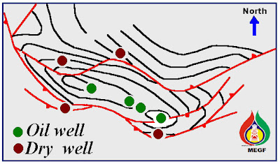
that most of the drilled wells were located of structures.

Geometry of Hamza Oil Field
a. Source Rocks and Maturation
The produced oil from Hamza oil field is genetically tied to the organic
rich rocks of the lower part of Wadi Es Sir formation (Turonian). The oil
generated from this interval is sweet (low sulfur), medium gravity (28 – 29
API). The initial oil generation triggered during the Eocene time. Significant
generation and migration of the oil occurred in Miocene time. The oil window of
this source rocks is 3000 meters. This depth equates to a temperature of 90
degrees C. The area down dip of 3000m,
such as the down thrown block of Fuluq Fault is considered of prime important
for oil generation. An estimated 430 million barrels of oil was generated from
this source rock only. Hamza oil field contains a small fraction of this oil
approximately 1 million barrels. If only 10% of this amount is trapped then 43
million barrels would be available in other undiscovered structures in the
basin.
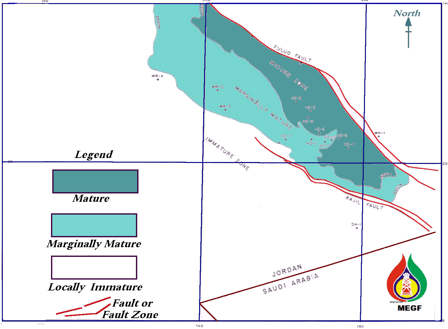
Maturity Map of the Turonian Source
The middle Cambrian Burj group
may provide possible oil source rock intervals, with varying richness and
thickness. They are possibly within the oil window on some paleo-high or in
shallow parts of the basin.
b. Reservoirs and Seals
Potential reservoir zones are
distributed within most of rocks in the geological column of the Azraq Basin.
Log interpretation, and core descriptions indicate that rocks with fair to good
reservoir quality are available in the Paleozoic, Alb/Apt and the Campanian
clastic, among these, the Alb/Apt.
Kurnub sandstone stands up with its excellent reservoir quality. A
strong oil shows was reported in these sands in HZ-14 well.
On the
other hand, there are two proven carbonates reservoirs of Cenomanian age, in
the basin; they are the Shueib and Hummer formations. Shueib is a dolomitized
carbonate shelf deposit; sucrosic with abundant intercrystalline and moldic
porosity enhanced by dolomitization and natural fractures. Both Wire line logs
and core analysis showed that the porosity of Shueib formation ranges from 7 -
10 % with 1.3 and 22.8 md calculated arithmetic permeability’s
respectively. The total thickness of this formation is 45 meters. By the same
token, Hummer formation consists of 45 meters carbonates, somewhat dolomite
towards the base. In general, due to the dense character of the Hummer
formation, the porosity and permeability values are much lower than Shueib
formation. Core analysis showed that an average porosity of 3.1% along with an
average arithmetic permeability of 2.2 md. The argillaceous limestone and shale
of Wadi Es Esir provide the seal.
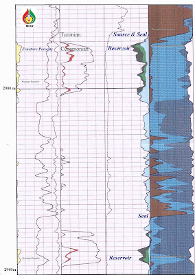
Hz-12
Well, Global Interpretation of (DLL, MSFL, LDT, ISF, BHC, NGT) Logs
c. Trap
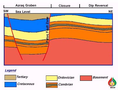
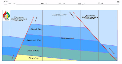
Hamza Oil field was discovered on top of an E/W tilted narrow horst
block, with steep flanks. The field is located in Hamza graben, which is a
principal sub-basin of the Azraq Graben.

X-Section Shows the Structural Configuration of Hz- Oil Field
Hamza graben is bounded by two NW/SE major faults, Fuluk left lateral
fault and Rajil fault. Hamza structure is possibly an old uplifted positive
flower structure. A later tensional tectonics phase may have formed the
pronounced horst. Closure along the horst is provided either by a anticlinal
flexure, or by narrowing of the horst block until the bounding faults join in
the up dip direction.

Hamza Oil Field Play Summary
Seismic
interpretation showed that there are grabens other than Hamza graben in the
basin, such as Northern Hamza Graben to the north of Hamza Field. This could be
an attractive structure for hydrocarbon exploration.
Fractures

Part of Structural Log (Hz-4 Well)
East / West fractures provided
migration pathways for the generated oil from the deeper part of the basin to
Hamza structure, even in dry wells these fractures were open and oil stained.
The Azraq Basin Block is now open for PSA
for more information


